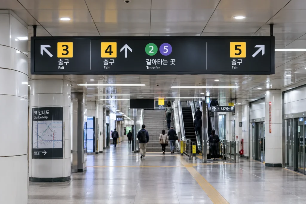
Korean subway exit numbers are one of the simplest tools for navigating Seoul once you understand how station signs are organized.
A subway station can have several entrances and exits spread across different blocks, intersections, shopping areas, and landmarks. Leaving through the wrong one can add several minutes of walking even when you arrived at the correct station.
The key is to pay attention to three things separately: the subway line, the station, and the exit number.
Korean subway exit numbers: the quick answer
When directions say something such as “City Hall Station, Exit 5,” the station name tells you where to get off and the exit number tells you which street-level exit to follow after leaving the train.
Inside the station, follow signs for your intended exit number rather than simply following the largest crowd.
For visitors, this is often more reliable than trying to remember which side of a large intersection a destination is located on.
Why exit numbers matter so much in Seoul
Seoul subway stations can cover a surprisingly large underground area.
Some stations connect multiple subway lines, underground shopping passages, office buildings, department stores, and several street intersections.
Two exits from the same station can therefore place you on very different streets.
A destination described as “three minutes from Exit 3” may be much less convenient if you accidentally leave through Exit 8.
Station name, line number, and exit number are different things
These numbers serve different purposes.
- Line number identifies the subway line, such as Line 2 or Line 5.
- Station information identifies the station itself and may include a station number.
- Exit number identifies a particular street-level exit from the station.
Do not confuse an exit number with a subway line number.
Seoul’s subway lines are color-coded
The official Seoul Metro map uses different colors and labels for the major subway and rail lines.
The Seoul Metropolitan Government redesigned the network map to make line recognition easier and to improve accessibility for international passengers.
Rather than relying only on station names, visitors can use line color and line number together when following a route.
Station numbers can help when Korean names are difficult
Station names are usually shown in Korean and English, but long or similar Korean place names can still be difficult for first-time visitors.
Station numbering provides another reference point.
Seoul’s redesigned subway-map system specifically added clearer line and station-number information to make stations easier for international passengers to identify.
When checking your route, compare the station name and number rather than relying on only one clue.
Transfer stations look different on the map
Transfer stations connect two or more subway or rail lines.
Seoul’s redesigned map uses a clearer transfer-station design that shows the colors of connected lines together.
This helps passengers identify which line they need to follow after leaving the first train.
Inside the station, transfer signs will guide you toward the connecting line rather than toward a street exit.
Do not follow an exit sign when you still need to transfer
This sounds obvious, but it is a common mistake when visitors are moving quickly through a large station.
If your route requires another subway line, follow the sign for the connecting line first.
Only begin following an exit number after you have reached your final station.
How to use exit numbers before you arrive
The easiest approach is to check your destination before getting off the train.
Use a local map or transit app to identify:
- Your destination station
- Your required exit number
- The direction you need to walk after exiting
Doing this before leaving the train reduces the amount of decision-making required inside a crowded station.
Why Exit 1 is not always the “main” exit
Visitors sometimes assume that Exit 1 must be the primary station entrance.
That is not a useful rule.
Exit numbers are navigation references, not quality rankings.
The best exit is simply the one closest to your destination.
Large stations can have many exits
Busy stations in central Seoul can serve several major roads and neighborhoods.
A station may therefore have many numbered exits.
In a large transfer station, you may need to walk through a long underground passage before reaching your chosen exit.
This is normal and does not necessarily mean you are going the wrong way.
Exit numbers are useful for meeting people
In Seoul, saying “meet at Exit 4” is often much clearer than saying “meet at the station.”
A large station can have entrances separated by several streets.
For travelers meeting friends, guides, or drivers, agreeing on both the station and exit number prevents unnecessary confusion.
Businesses often give directions by subway exit
Korean businesses, attractions, government offices, and event pages commonly describe their location using the nearest subway station and exit.
For example, Seoul Metropolitan Government’s own directions to City Hall specify both the subway station and the recommended exit.
This makes exit numbers part of everyday address and navigation language in Seoul.
Look for arrows, not just the number
When an exit number appears on a directional sign, the arrow matters.
A station can have several corridors branching in different directions.
Continue checking the signs at each junction until you actually reach the exit.
Do not assume that seeing your exit number once means the rest of the route is straight ahead.
Why Korean and English station names can look different
English names are romanized versions of Korean place names.
Some station names can appear long, especially when they include universities, government facilities, or district names.
For this reason, line color, line number, station number, and exit number are useful backup clues.
What does a transfer symbol mean?
On a subway map, a transfer symbol means that passengers can change between connected lines at that station.
Seoul’s updated map design emphasizes transfer stations more clearly so passengers can recognize the connected lines more quickly.
This is especially helpful in stations where three or more routes intersect.
How to know which direction the train is going
Before boarding, check the direction indicated by the next major stations or the terminal direction shown on the platform information.
Do not assume that the same line color means both platforms travel in the same direction.
If you are unsure, compare the next station on your route with the station information displayed on the platform.
Use the station map when exits are complicated
Many stations display local-area maps near exits and concourses.
These can help you see which exit leads to a specific road, building, landmark, or intersection.
If your destination is not obvious, compare the map with the exit number recommended by your navigation app.
The official Seoul Subway app can help inside stations
Seoul Metropolitan Government provides an official subway app that includes route search and station information.
The city says the service can provide information about station exits and restrooms, and some stations support more detailed indoor navigation.
This can be useful when a large station layout is more complicated than a simple route map suggests.
Why map apps are useful even after you choose an exit
The exit number gets you to the correct part of the street.
It does not automatically mean your destination will be directly in front of you.
Once outside, check your walking direction again.
This is particularly helpful around large intersections where roads may curve or several buildings have similar entrances.
What if your chosen exit is closed?
Subway exits can occasionally be closed temporarily because of construction, maintenance, large events, or crowd management.
Seoul sometimes publishes temporary exit closures for major events.
If your planned exit is unavailable, follow station staff instructions or use the nearest open exit and recalculate the walking route outside.
Elevators may not be located at your preferred exit
Travelers with luggage, wheelchairs, or strollers should not assume every exit has an elevator.
The closest numbered exit to your destination may not be the easiest accessible route.
When accessibility matters, check station facility information before choosing the exit.
Subway exits can connect directly to buildings
Some stations connect directly to underground shopping centers, department stores, offices, or other buildings.
In these cases, the easiest route may keep you indoors for part of the journey.
Follow the specific building or exit signs rather than automatically heading to street level.
A practical routine for first-time visitors
Before arriving at your station:
- Confirm the station name.
- Confirm the subway line.
- Check the recommended exit number.
- Screenshot or remember the exit number.
- After leaving the train, follow exit signs only after completing any transfers.
- Check your walking direction again once outside.
Common subway navigation mistakes
Typical mistakes include:
- Leaving the station before making a required transfer
- Following the crowd instead of the correct exit
- Confusing a line number with an exit number
- Assuming Exit 1 is always the main exit
- Ignoring the walking direction after reaching street level
- Choosing the closest exit without checking accessibility needs
Why exit numbers are easier than memorizing streets
Visitors do not need to understand every surrounding road immediately.
An exit number acts as a simple bridge between the subway network and street navigation.
Instead of remembering a complex underground layout, you only need to identify the correct exit and then continue your route above ground.
Bottom line
Korean subway exit numbers make Seoul much easier to navigate when you treat them as a separate step from choosing the subway line and station.
First get to the correct station. Complete any transfers. Then follow the numbered exit recommended for your destination.
Combine the exit number with line colors, station names, station numbers, directional arrows, and a local navigation app, and even large Seoul subway stations become much easier to understand.
Related BestSpot Guides
- Naver Map vs KakaoMap vs Google Maps in Korea
- why Google Maps works differently in South Korea
- essential apps for South Korea travel
Sources
- Seoul Metropolitan Government — 2026 Seoul Metro Map
- Seoul Metropolitan Government — Public Transportation and Seoul Subway App
- Seoul Metropolitan Government — Seoul Metro Map Redesign
- Seoul Metropolitan Government — City Hall Subway Exit Directions
Updated: September 2026. Station layouts, exit access, line information, and temporary closures can change. Check current station signs and transit information during your trip.